 |
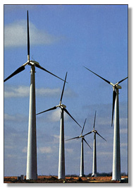
The U.S. Department of Energy has updated maps of the country’s wind power capacity because of advances in wind turbine technologies.
Updated maps were released in December by the federal energy agency and show how taller wind turbines with higher nacelles and longer blades can capture significant amounts of wind power.
Resource maps demonstrate a geographic region’s wind energy capacity factor by highlighting areas of the country where wind speeds would allow a wind farm to produce at least 35 percent of the electricity it could potentially produce, if it were running continuously at full power.
In Nebraska, virtually the entire state, except Omaha, is rated at 35 percent gross capacity factor at both 110 and 140 meters.
Earlier maps depicted areas with a wind energy capacity of at least 35 percent for wind turbines whose hubs and nacelles are at heights of 30 to 100 meters, or up to 328 feet. The new maps now include taller turbines with hub heights up to 140 meters.
The U.S. Department of Energy has been working with the wind industry to produce taller wind turbines with longer blades because wind speeds are often greater at higher altitudes, thus increasing energy production potential. The federal energy agency estimates that deploying turbines with hub heights up to 140 meters would help access 237,000 square miles of the United States with 1,800 gigawatts in wind power resource potential.
The maps do not include areas protected by law such as national parks.