Wind Speeds at 80 Meters...
New Nebraska Wind Map Available
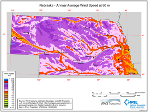
The Department of Energy's Wind Program and the National Renewable Energy Laboratory published a new wind resource map for the state of Nebraska. The new wind resource map shows the predicted mean annual wind speeds at 80 meters height. Areas with average annual wind speeds of 6.5 meters per second (15 miles per hour) and greater at 80 meters height are generally considered to have suitable wind resource for wind development.
A Collaborative Effort
These maps and wind potential estimates resulted from a collaborative project between the National Renewable Energy Laboratory and AWS Truewind of Albany, New York. This is the first comprehensive update of the wind energy potential in Nebraska since 1993. The Renewable Laboratory has worked with AWS Truewind for almost a decade on updating wind resource maps for 36 states and producing validated maps for 50 meter height above ground. U.S. Department of Energy's Wind Powering America project supported the mapping efforts. The Nebraska 30, 50, 70 and 100 meter wind maps are still available.
Additionally, a national dataset was produced of estimated gross capacity factor at a spatial resolution of 200 m and heights of 80 meters and 100 meters. Using AWS Truewind's gross capacity factor data, the Laboratory estimated the windy land area and wind energy potential in various capacity factor ranges for each state. A table lists the estimates of windy land area with a gross capacity of 30 percent and greater at 80 meter height and the wind energy potential from development of the "available" windy land area after exclusions.
The "Installed Capacity" is the potential megawatts of rated capacity that could be installed on the available windy land area, and the "Annual Generation" is the estimated annual wind energy generation in gigawatt-hours that could be produced from the installed capacity. The Laboratory reduced the wind potential estimates by excluding areas unlikely to be developed such as wilderness areas, parks, urban areas, and water features.
Wind resource at a micro level can vary significantly. Landowners should get a professional evaluation of the specific land area.